Many areas of the West Cumbrian environment are contaminated by Sellafield’s radioactive fingerprint, where radioactivity from the plant’s sea discharge material is trapped particularly in the muddy docks, harbours and estuaries up and down the coast. Some of the highest levels of radioactive contamination are found in the publicly accessible saltmarshes at Newbiggin, south of Muncaster Bridge, where the River Esk flows into the Irish Sea via Ravenglass. The radionuclides found in the sediments and their levels of radioactivity provide a snap-shot in time of Sellafield’s excessive discharge history.
The extent of the pollution was brought home to Cumbrians by CORE in a protest against Sellafield’s discharges. Campaigners took a dustbin full of silt and mud from the Ravenglass estuary, five miles south of Sellafield and dumped it in London, near the Prime Minister’s official residence. The area was immediately cordoned off by police and the mud had to be disposed of as low-level radioactive waste.
Regular monitoring by CORE and others has revealed levels of Caesium 137 of 13000 Bq/kg, Americium 241 of 27000Bq/kg and Plutonium of over 10,000Bq/kg in sample materials analysed by independent hospital and university laboratories. These high levels significantly breach the 4000Bq/kg classification for low level waste (LLW), and should require the materials to be properly disposed of and safely contained in a licensed waste dump. By comparison, some of these local levels would not be permitted on working surfaces inside Sellafield, would exceed legal limits in BNFL’s customer countries, and are greater than some levels found in the 30km exclusion zone around Chernobyl from which the public is banned and agricultural and general land use is forbidden.
In complete contrast, ‘official’monitoring figures provided by BNFL, MAFF and the Environment Agency show greatly reduced levels, up to forty times less than CORE and other figures. Official sampling involves just a 2cm surface sample scrape of material which clearly cannot and does not reflect the significantly higher levels of radioactivity which, over the years, have been trapped and embedded in the silt to depths of over 30cm, but which remain accessible to the public via work and leisure activities.
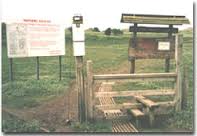
Contaminated public entrance to Nature Reserve
The estuary area, around 12km south of Sellafield and used by locals for grazing livestock, fishing and bait-digging, and by visitors for horse-riding, bird watching, walking and cycling, also includes a nature reserve. Levels of radioactivity in material even at the public entrance to the reserve are such that it too is classified as LLW, yet no signs are provided at the reserve, or at any of the other contaminated areas in West Cumbria to warn of the radiation hazards. One local brochure even invites walkers, following the Cumbria Coastal Way footpath which passes around the estuary, to take a short cut across the River Esk at low tide through some of the most contaminated areas.